Saturday 30 July 2016

Ancient City of Ping Yao

Ping Yao used to be a financial centre of China, now it's a major touristic attraction mainly because of the wonderful and well preserved city walls
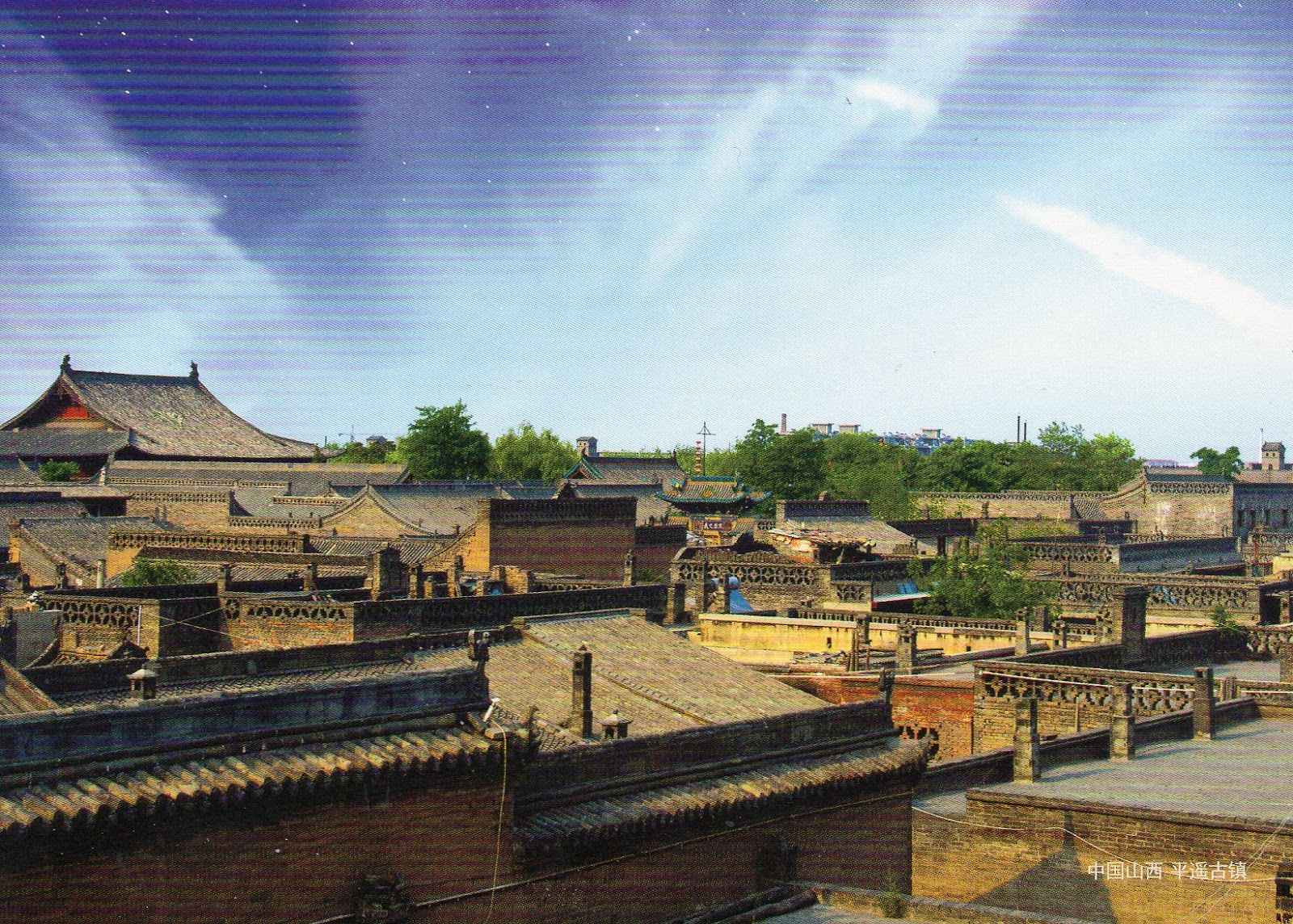
Ping Yao
Ping Yao is an exceptionally well-preserved example of a traditional Han Chinese city, founded in the 14th century. Its urban fabric shows the evolution of architectural styles and town planning in Imperial China over five centuries. Of special interest are the imposing buildings associated with banking, for which Ping Yao was the major centre for the whole of China in the 19th and early 20th centuries. - in: http://whc.unesco.org/en/list/812

Ping Yao city walls
The city walls of Pingyao were constructed in the 3rd year of the Hongwu Emperor (1370). The walls have six barbican gates. The north and south sides have one gate each. The east and west sides have two gates each. This pattern is similar to that of a turtle (the head, tail and four legs), earning Pingyao the moniker "Turtle City." The walls measure about 12 metres high, with aperimeter of 6,000 metres. A 4-metre wide, 4-metre deep moat can be found just outside the walls. Aside from the four structured towers at the four corners, there are also 72 watchtowers and more than 3,000 battlements. In 2004, part of the southern walls collapsed but were reconstructed. However, the rest of the city walls are still largely intact and are considered among the best-preserved ancient city walls on this scale. This makes the city walls the centrepiece of the Heritage Site. - in: wikipedia

Ancient Villages in Southern Anhui – Xidi and Hongcun

Sometimes is hard to tell exactly from where are the views shown in the postcards. In the case of these two I have no doubt that they are from the ancient villages in Southern Anhui, but not sure if they are from Xidi or from Hongcun. The sender of the first postcard says it is Xidi and the sender of second says it is Hongcun. However, after googling some images, I think they are both from Hongcun.

Ancient Village in Southern Anhui
Xidi (Chinese西递) is a village in Yi County of the historical Huizhou region of Anhui province, China.
First built during the Huangyou era (1049–1053) of Song Dynasty Emperor Renzong, the village was originally called Xichuan (West River), owing to the various water courses flowing through it.
The rise of the village was closely tied to the fortunes of the Hu family. By 1465 CE, during the Ming Dynasty (1368–1644), family members had started in business as merchants, leading to construction of major private buildings and a public infrastructure. By the middle of the 17th century, the influence wielded by members of the Hu family expanded from commerce into politics. The prosperity of Xidi peaked in the 18th and 19th centuries, at which time the village comprised about 600 residences.

Ancient Village in Southern Anhui
Hongcun (Chinese宏村pinyinHóngcūnlit. "Hong village") is a village in Yi County in the historical Huizhou region of southern Anhui Province, China, near the southwest slope of Mount Huangshan.
The village is arranged in the shape of an ox with the nearby hill (Leigang Hill) interpreted as the head, and two trees standing on it as the horns. Four bridges across the Jiyin stream can be seen as the legs whilst the houses of the village form the body. Inside the “body”, the Jiyin stream represents the intestines and various lakes such as the “South Lake” (Nanhu) form the other internal organs.
The architecture and carvings of the approximately 150 residences dating back to the Ming and Qing Dynasties are said to be among the best of their kind in China. One of the biggest of the residences open to visitors, Chenzhi Hall, also contains a small museum. - in: wikipedia

Friday 29 July 2016

Ancient City of Tauric Chersonese and its Chora

A little bit of Greece in Ukraine 

Ruins of Chersonese
This postcard was sent by Sergii

Chersonesus (also rendered as ChersoneseChersonesos), in medieval Greek contracted to Cherson, is an ancient Greek colony founded approximately 2,500 years ago in the southwestern part of the Crimean Peninsula. The colony was established in the 6th century BC by settlers from Heraclea Pontica.
The ancient city is located on the shore of the Black Sea at the outskirts of Sevastopol on the Crimean Peninsula, where it is referred to as Khersones. It has been nicknamed the "Ukrainian Pompeii". The site is now part of the National Preserve of Tauric Chersonesos. The name "Chersonesos" in Greek means "peninsula", and aptly describes the site on which the colony was established. - in: wikipedia

Thursday 28 July 2016

Residence of Bukovinian and Dalmatian Metropolitans

This amazing complex of buildings is one of the Seven Architectural Wonders of Ukraine

Residence of Bukovinian and Dalmatian Metropolitans
This postcard was sent by Sergii

The Residence of Bukovinian and Dalmatian Metropolitans in ChernivtsiUkraine was built between the years 1864 - 1882 to the designs of the Czech architect, Josef Hlávka. The Residence, whose buildings are now part of Chernivtsi University, was declared a UNESCO World Heritage Site in 2011.
The buildings of the complex are laid out on three sides of a courtyard which is approximately 100 metres deep and 70 metres wide: the fourth side of this yard contains the main gates, set in tall railings. - in: wikipedia

Wednesday 27 July 2016

Old Rauma

Rauma is a wooden city and one of the oldest harbours in Finland

Old Rauma
This postcard was sent by Sonja

Situated on the Gulf of Bothnia, Rauma is one of few medieval towns in Finland. The core of the town is Old Rauma, which is composed of some 600 buildings constructed of wood, most of which are privately owned, and covers an area of 29 ha. Originally situated at the seashore, the Old Town is located some 1.5 km inland from the present coastline due to land uplift. Old Rauma is both a commercial and a residential area comprising the town area within the toll boundaries of Rauma in the 19th century.

Old Rauma
This postcard was sent by Stasa

The commercial area is located along two main streets stretching through the Old Town, while the Market Square, in the middle of the Old Town, forms the main meeting point and commercial place for local people and producers. The medieval church, built around a Franciscan monastery, and the former Town Hall built in 1775-76 in the Market Square are landmarks in the harmonious townscape of one-storey residential and commercial buildings. The architecturally homogenous urban area of Old Rauma is a well preserved and representative example of traditional Nordic wooden town building techniques and traditions. - in: http://whc.unesco.org/en/list/582

Friday 22 July 2016

Archaeological Site of Ani

The UNESCO committee inscribed last week 21 new properties. Of those 21, Ani in Turkey is the only one that I already had

Churh of Saint Gregory of Tigran Honents
This postcard was sent by Cuneyt

This church, finished in 1215, is the best-preserved monument at Ani. It was built during the rule of the Zakarids and was commissioned by the wealthy Armenian merchant Tigran Honents. Its plan is of a type called a domed hall. In front of its entrance are the ruins of a narthex and a small chapel that are from a slightly later period. The exterior of the church is spectacularly decorated. Ornate stone carvings of real and imaginary animals fill the spandrels between blind arcade that runs around all four sides of the church. The interior contains an important and unique series of frescoes cycles that depict two main themes. In the eastern third of the church is depicted the Life of Saint Gregory the Illuminator, in the middle third of the church is depicted the Life of Christ. Such extensive fresco cycles are rare features in Armenian architecture – it is believed that these ones were executed by Georgian artists, and the cycle also includes scenes from the life of St. Nino, who converted the Georgians to Christianity. In the narthex and its chapel survive fragmentary frescoes that are more Byzantine in style. - in: wikipedia

Thursday 21 July 2016

Maloti-Drakensberg Park

The Maloti-Drakensberg Park is a transboundary site composed of the uKhahlamba Drakensberg National Park in South Africa and the Sehlathebe National Park in Lesotho

Drakensberg
This postcard was sent from Germany sent by Gisela, who lived in South Africa from 2006 to 2010

The uKhahlamba-Drakensberg Park is in the KwaZulu-Natal province of South Africa, covering 242,813 ha (2,428 km2) of area. The park includes Royal Natal National Park, a provincial park, and covers part of the Drakensberg, the highest mountain range in Southern Africa.
The Drakensberg mountain range is characterized by a high level of endemism of both invertebrates and vertebrates. - in: wikipedia

I still need a postcard from the Sehlathebe National Park in Lesotho 

Robben Island

Nelson Mandela was imprisoned in this island for 18 years. Today the island is a popular tourist destination.

Robben Island
This postcard arrived from Germany sent by Gisela

Robben Island was used at various times between the 17th century and the 20th century as a prison, a hospital for socially unacceptable groups, and a military base. Its buildings, and in particular those of the late 20th century maximum security prison for political prisoners, testify to the way in which democracy and freedom triumphed over oppression and racism.
What survives from its episodic history are 17th century quarries, the tomb of Hadije Kramat who died in 1755, 19th century ‘village’ administrative buildings including a chapel and parsonage, small lighthouse, the lepers’ church, the only remains of a leper colony, derelict World War II military structures around the harbour and the stark and functional maximum security prison of the Apartheid period began in the 1960s.
The symbolic value of Robben Island lies in its somber history, as a prison and a hospital for unfortunates who were sequestered as being socially undesirable. This came to an end in the 1990s when the inhuman Apartheid regime was rejected by the South African people and the political prisoners who had been incarcerated on the Island received their freedom after many years. - in: http://whc.unesco.org/en/list/916

Thursday 14 July 2016

Fraser Island

The Fraser Island, besides of all its natural beauty, is also known by the wreck of the S.S. Maheno 

Fraser Island

This postcard arrived from Indonesia sent by Shinta

Fraser Island, also known by its Aboriginal name of K’gari, lies along the eastern coast of Australia. The property covers 181,851 hectares and includes all of Fraser Island and several small islands off the island's west coast. It is the world’s largest sand island, offering an outstanding example of ongoing biological, hydrological and geomorphological processes.  The development of rainforest vegetation on coastal dune systems at the scale found on Fraser Island is unique, plus the island boasts the world’s largest unconfined aquifer on a sand island.

Fraser Island
This postcard was sent by Norma

The property has exceptional natural beauty with over 250 kilometres of clear sandy beaches with long, uninterrupted sweeps of ocean beach, strikingly coloured sand cliffs, and spectacular blowouts. Inland from the beach are majestic remnants of tall rainforest growing on sandy dunes and half of the world’s perched freshwater dune lakes. - in: http://whc.unesco.org/en/list/630

Urnes Stave Church

An amazing church with an amazing view!

Urnes Stave Church
This postcard was sent by Jo

Urnes Stave Church (NorwegianUrnes stavkyrkje) is a 12th-century stave church at Ornes, along the Lustrafjorden in the municipality of Luster in Sogn og Fjordane county, Norway. It sits on the eastern side of the fjord, directly across the fjord from the village of Solvornand about 5 kilometres (3.1 mi) east of the village of Hafslo.
The church was built around 1130 or shortly thereafter, and still stands in its original location; it is believed to be the oldest of its kind. It provides a link between Christian architecture and the architecture and art forms of the Viking Age with typical animal-ornamentation, the so-called "Urnes style" of animal-art. - in: wikipedia

Wednesday 13 July 2016

Tokaj Wine Region Historic Cultural Landscape

In this new century a lot of wine regions have been inscribed in the world heritage list. Tokaj was one of them

Tokaj Cellar
This postcard was sent from Poland by Malgosia who says that Tokaj wines are very popular in her country

Located at the foothills of the Zemplén Mountains (in North-East Hungary), along the Bodrog river and at the confluence of the Bodrog and the Tisza Rivers, the Tokaj Wine Region Historic Cultural Landscape was inscribed on the World Heritage List in 2002. (...) The entire landscape, its organisation and its character are specially shaped in interaction with the millennial and still living tradition of wine production. Documented history of the wine region since 1561 attests that grape cultivation as well as the making of the ‘aszú’ wine has been permanent for centuries in the area surrounded by the three Sátor-hegy (the Tokaj-hill, the Sátor – hill of Abaújszántó, and the Sátor-hill of Sátoraljaújhely). The legal base of delimitation of the wine region is among the first in the world and dates back to 1737 when the decree of Emperor Charles VI (Charles III, King of Hungary) established the area as a closed wine region.
The unique combination of topographic, environmental and climatic conditions of the Tokaj Wine Region, with its volcanic slopes, wetlands creating a special microclimate that favours the apparition of the “noble rote” (Botrytis cinerea), as well as the surrounding oak-woods have long been recognized as outstandingly favourable for grape cultivation and specialized wine production. All these features have enabled the development of vineyards, farms, villages, small towns and historic networks of wine cellars carved by hand into mostly volcanic rocks, which are the most characteristic structures in Tokaj: that of King Kalman in Tarcal is known to have been in existence as early as 1110. There are two basic types of cellar in Tokaj: the vaulted and the excavated. - in: http://whc.unesco.org/en/list/1063/

Sunday 10 July 2016

Convent of Christ in Tomar

In 2009 my wife and I were still in Portugal and she was sad because her parents had moved to Switzerland. To cheer her up we spent a wonderful weekend in the center region of Portugal which included a visit to the wonderful Convent of Christ in Tomar.

Round Church of the Convent of Christ
The Convent of Christ (PortugueseConvento de Cristo) is a former Roman Catholic convent/monastery in the civil parish of Tomar (São João Baptista) e Santa Maria dos Olivais, in the Centrol region municipality of Tomar

Convent of Christ
This postcard was sent by José "PilotOne"

Originally a 12th-century Templar stronghold, when the order was dissolved in the 14th century the Portuguese branch was turned into the Knights of the Order of Christ, that later supported Portugal's maritime discoveries of the 15th century. The Convent and Castle complex is a historic and cultural monument which was listed in the list of UNESCO World Heritage list in 1983.

Interior of the Rotunda
The Romanesque round church is a Roman Catholic Church from the castle (charolarotunda) was built in the second half of the 12th century by the Knights Templar. From the outside, the church is a 16-side polygonal structure, with strong buttresses, round windows and a bell-tower. Inside, the round church has a central, octagonal structure, connected by arches to a surrounding gallery (ambulatory). The general shape of the church is modelled after similar round structures in Jerusalem: the Mosque of Omar and the Church of the Holy Sepulchre.
The interior of the round church is magnificently decorated with late gothic/manueline sculpture and paintings, added during a renovation sponsored by King Manuel I starting in 1499. The pillars of the central octagon and the walls of the ambulatory have polychrome statues of saints and angels under exuberant Gothic canopies, while the walls and ceilings of the ambulatory are painted with Gothic patterns and panels depicting the life of Christ. The paintings are attributed to the workshop of the court painter of Manuel I, the Portuguese Jorge Afonso, while the sculptured decoration is attributed to Flemish sculptor Olivier de Gand and the Spaniard Hernán Muñoz. A magnificent panel depicting the martyrdom of Saint Sebastian, by Portuguese painter Gregório Lopes, was painted for the Round Church and now hangs in the National Museum of Ancient Art in Lisbon.

Window of the Chapter
The so-called Window of the Chapter House (Janela do Capítulo), a huge window visible from the Saint Barbara Cloister in the Western façade of the nave, carries most of the typical Manueline motifs: the symbols of the Order of Christ and of Manuel I, and fantastic and unprecedented elaborations of ropes, corals and vegetal motifs. A human figure in the bottom of the window probably represents the designer, Diogo de Arruda. This window of the Convent constitutes one of the masterworks of Manueline decoration.

Church Main Door
The entrance of the church is done through a magnificent lateral portal, also decorated with abundant Manueline motifs and statues of the Virgin with the Child as well as the Prophets of the Old Testament. This portal was designed by João de Castilho around 1530.

Detail of the Church Main Door
This postcard was sent by José "PilotOne"

Gargoyle in the Convent of Christ
This postcard was sent by José "PilotOne"


Thursday 7 July 2016

Museumsinsel (Museum Island), Berlin

I'm pretty sure I would be delighted to visit all these museums!

Museum Island
This postcard was sent by Claus

Museum Island (GermanMuseumsinsel) is the name of the northern half of an island in the Spree river in the central Mitte district of BerlinGermany, the site of the old city of Cölln. It is so called for the complex of five internationally significant museums, all part of the Berlin State Museums, that occupy the island's northern part:
In 1999, the museum complex was added to the UNESCO list of World Heritage Sites. - in: wikipedia

Þingvellir National Park

Þingvellir is one of the most popular tourist destinations in Iceland due to its historical, cultural, and geological importance. 

Þingvellir National Park
This postcard was sent from Switzerland by Isabella

Þingvellir (Thingvellir) is the National Park where the Althing, an open-air assembly representing the whole of Iceland, was established in 930 and continued to meet until 1798. Over two weeks a year, the assembly set laws - seen as a covenant between free men - and settled disputes. The Althing has deep historical and symbolic associations for the people of Iceland. The property includes the Þingvellir National Park and the remains of the Althing itself: fragments of around 50 booths built from turf and stone. Remains from the 10th century are thought to be buried underground. The site also includes remains of agricultural use from the 18th and 19th centuries. The park shows evidence of the way the landscape was husbanded over 1,000 years. - in: http://whc.unesco.org/en/list/1152

Surtsey

It's hard to imagine that only 60 years ago this island didn't exist!

Surtsey
This postcard was sent by Patrik

Surtsey, a volcanic island approximately 32 km from the south coast of Iceland, is a new island formed by volcanic eruptions that took place from 1963 to 1967. It is all the more outstanding for having been protected since its birth, providing the world with a pristine natural laboratory. Free from human interference, Surtsey has been producing unique long-term information on the colonisation process of new land by plant and animal life. Since they began studying the island in 1964, scientists have observed the arrival of seeds carried by ocean currents, the appearance of moulds, bacteria and fungi, followed in 1965 by the first vascular plant, of which there were 10 species by the end of the first decade. By 2004, they numbered 60 together with 75 bryophytes, 71 lichens and 24 fungi. Eighty-nine species of birds have been recorded on Surtsey, 57 of which breed elsewhere in Iceland. The 141 ha island is also home to 335 species of invertebrates. - in: http://whc.unesco.org/en/list/1267

Monday 4 July 2016

Rietveld Schröderhuis (Rietveld Schröder House)

At first sight we might wonder why such an ordinary house is a UNESCO World Heritage Site, but when we know that this house was built in the 1920's we realize that was not that ordinary for its time

Rietveld Schröder House
This postcard was sent by Kim

The Rietveld Schröder House (DutchRietveld Schröderhuis) (also known as the Schröder House) in Utrecht was built in 1924 by Dutch architect Gerrit Rietveld for Mrs. Truus Schröder-Schräder and her three children.
She commissioned the house to be designed preferably without walls. Rietveld worked side by side with Schröder-Schräder to create the house. He sketched the first possible design for the building; Schröder-Schrader was not pleased. She envisioned a house that was free from association and could create a connection between the inside and outside. The house is one of the best known examples of De Stijl-architecture and arguably the only true De Stijl building. Mrs. Schröder lived in the house until her death in 1985. The house was restored by Bertus Mulder and now is a museum open for visits, run by the Centraal Museum. It is a listed monument since 1976 and UNESCO World Heritage Site since 2000. - in: wikipedia